Weisen Shen's Research Highlights
Weisen Shen (weisen.shen@colorado.edu)
Ph.D., Geophysics, University of Colorado Boulder
Postdoc Research Associate, Center for Imaging the Earth's Interior,
Department of Physics, University of Colorado Boulder
As an observational seismologist, I have been focusing on developing the seismic inversion methods to image the earth's crustal and uppermost mantle structures utilizing multiple seismic observables (i.e., surface waves extracted from both ambient noise and teleseismic earthquakes, receiver functions, local amplification measurements) produced at large seismic arrays. These studies are summarized in multiple research papers listed in my Curriculum Vitae, and are described briefly below. Overall, my study contributes to a better understanding of the physical attributes of the earth such as wave speeds, anisotropy, and location of the discontinuities.
Ongoing Research Porjects
At present, I am working on building two isotropic shear velocity models at continental scales: 1) the North America crust and uppermost mantle model using USArray; 2) the East Asia crust and uppermost mantle model using various arrays deployed in China and the nearby areas. Using the techniques I developed during graduate school and combining multiple seismic measurements (surface wave dispersion measured from both ambient noise and earthquakes; receiver functions; and Rayleigh wave H/V ratio measurements), both the horizontal and vertical resolutions of the models will be greatly improved. Moreover, the uncertainties of the two shear velocity models will be also obtained from a Bayesian Monte Carlo inversion algorithm.
Research Projects Prior to 2014
Seismic Investigation of the Midcontinental Rift (MCR) Zone
Project Summary
In this work, the joint Bayesian Monte-Carlo inversion described below is applied to 122 USArray/TA stations in the central US encompassing the Midcontinent Rift (MCR), and a three dimensional Vs model for the crust and uppermost mantle is constructed, providing an overview of the seismic structure of the MCR and adjacent area. The tectonic implications from the resulting 3-D model in detail lead to three major conclusions. 1) In the central US, a high correlation between the long wavelength gravity field and shallow Vs structure is observed and the MCR gravity high is obscured by clastic sediments in the shallow crust, which is consistent with an upper crustal origin to the MCR gravity anomaly as well as other anomalies in the region. 2) Thick crust (>47 km) underlies the MCR, which is evidence for post-rifting compression along the entire rift. 3) Crustal shear wave speeds vary across the Precambrian sutures (e.g., Great Lakes Tectonic Zone, Spirit Lakes Tectonic Zone), which reveals that the Precambrian sutures played an important role in the subsequent tectonic evolution of the central US.
Project Products
Shen, W., M.H. Ritzwoller, and V. Schulte-Pelkum, Crustal and uppermost mantle structure in the central US encompassing the Midcontinent Rift, J. Geophys. Res., 118, 4325-4344, doi:10.1002/jgrb.50321, 2013. (pdf)
 |
Vertical transects of the means of the posterior distribution of Vsv along profiles across the MCR region. In the upper panel of each pair, absolute shear velocity (kms) is shown in the crust, the Moho is identified by the thick dashed line, and percent perturbation relative to 4.65 kms is presented in the mantle. In the lower panel of each pair, receiver functions at stations close to the transects are shown as black waveforms and filled with warm color for positive amplitudes and cool colors for negative amplitudes. |
A 3-D crust and uppermost mantle structure of western US
Project Summary
An important application of the joint inversion of surface wave dispersion and receiver function method is the USArray. In this project I process both ambient noise tomography and earthquake tomography to the USArray transportable stations deployed between 2005 to 2010. High resolution surface wave dispersion maps are generated with period band of 8 to 80 sec. Over 1500 teleseismic events are used to generate receiver functions and the harmonic stipping method is applied. I then apply the MCMC joint inversion to both data sets constructing a 3-D model of the crust and uppermost mantle for western US. Vertical resolution is improved compared with earlier generation of 3-D models. By using receiver functions, the structure at the lower crust and uppermost mantle are better constrained. Various tectonic features are found in the 3-D model and call for further interpretation.
Project Products
A high-resolution 3-D crust and uppermost mantle model for US west of 100W. The model is to a depth of 150 km, and with uncertainties. A research paper is published in JGR:
Shen, W., M.H. Ritzwoller, and V. Schulte-Pelkum, A 3-D model of the crust and uppermost mantle beneath the central and western US by joint inversion of receiver functions and surface wave dispersion, J. Geophys. Res., doi:10.1029/2012JB009602, 2013
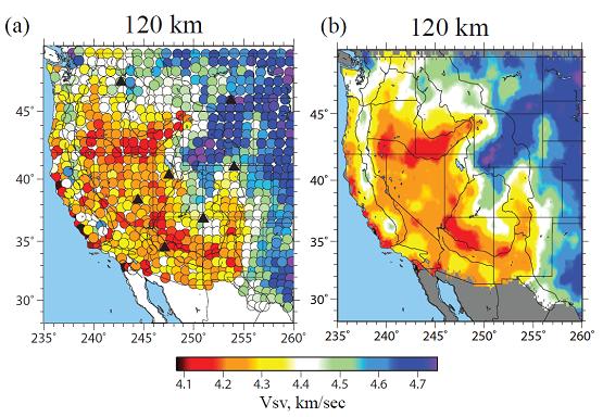 |
(a) Average of Vsv from the distribution of accepted models from the joint inversion in the depth range from 105 to 135 km, presented as a mosaic of results at each station location. (b) The same as (a), but wave speeds have been interpolated onto a 0.25 deg * 0.25 deg from simple-kriging, in which model uncertainties guide the interpolation. (Shen et al. 2013) |
Joint inversion of receiver functions and surface wave using Bayesian Monte Carlo method
Project Summary
Joint interpretation multiple seismic data sets such as surface wave dispersion and receiver functions has been proposed for decades but not applied to large seismic array at continental scales yet. In this research project I develop an algorithm that inverts the latest surface wave dispersion measurements and receiver functions into simple Vs model for seismic arrays. This algorithm includes a harmonic stripping process for receiver functions, a Markov Chain Monte Carlo (MCMC) sampling code, and a kriging scheme that constructs a 3-D model. It is tested in the inter-mountain west region with 200 seismic stations. After the inversion, a 3-D model with uncertainties for the test region is obtained.
Project Products
A joint inversion of surface wave and receiver function algorithm; a 3-D model for the inter-mountain west. A research paper published in GJI:
Shen, W., M.H. Ritzwoller, V. Schulte-Pelkum, F.-C. Lin, Joint inversion of surface wave dispersion and receiver functions: A Bayesian Monte-Carlo approach, Geophys. J. Int., Geophys. J. Int., doi: 10.1093/gji/ggs050, 2012.
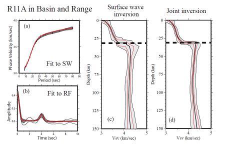 |
Example outcome of the joint inversion at USArray TA station R11A in the Basin and Range province in Currant, Nevada (38.35, -115.59). (a) Observed Rayleigh wave phase speed curve presented as 1 sigma error bars. Predictions from the ensemble of accepted models in (d) are shown (grey lines), as is the prediction from the best fitting model (redline). (b) The azimuthally independent receiver function R0(t) is shown with the black lines defining the estimated 1 sigma uncertainty. Predictions from the members of the ensemble in (b) are shown with grey lines, and the red line is the best fitting member of the ensemble. (c) Ensemble of accepted model using surface wave data alone. The full width of the ensemble is presented as black lines enclosing a grey-shaded region, the 1 sigma width is shown with red lines, and the average model is the black curve near the middle of the ensemble. Moho is identified as a dashed line at 32 km. (b) Ensemble of accepted models from the joint inversion (Shen et al. 2012). |
Surface wave tomography for E. Asia
Project Summary
Recent development in large seismic array in China (CEArray) and Japan (F-net) allows us to make better 3-D model by using the latest surface wave methods: Ambient Noise tomography (ANT). With collaborators in from multiple institutes at China/Australia, I am able to apply the ANT to 1) Northeastern China and Sea of Japan; 2) South China; and 3) Tibetan Plateau. Totally over 200,000 ambient noise cross-correlations are generated from stations with over 10 years seismic data; straight ray tomography and the latest eikonal tomography method are used to generate high resolution surface wave dispersion maps. A modified Monte Carlo inversion algorithm is designed to invert surface wave dispersion to 3-D crustal and uppermost mantle models for each of the study region. In the project, I also locate an anomalous noise source at Kyshu island, Japan, and develop a quality control scheme to remove the effect to the empirical Green's function from it.
Project Products
3-D models for crust and uppermost mantle in Northeastern China/Sea of Japan, South China and Tibetan Plateau; 3 research papers published in JGR/GJI:
Zhou, L., J. Xie, W. Shen, Y. Zheng, Y. Yang. H. Shi, and M.H. Ritzwoller, The structure of the crust and uppermost mantle beneath South China from ambient noise and earthquake tomography, Geophys. J. Int., doi: 10.1111/j.1365-246X.2012.05423.x, 2012.
Zheng, Y., W. Shen, L. Zhou, Y. Yang, Z. Xie, and M.H. Ritzwoller, Crust and uppermost mantle beneath the North China Craton, northeastern China, and the Sea of Japan from ambient noise tomography, J. Geophys. Res., 116, B12312, doi:10.1029/2011JB008637, 2011.
Yang, Y., M.H. Ritzwoller, Y. Zheng, W. Shen, A.L. Levshin, and Z. Xie, A synoptic view of the distribution and connectivity of the mid-crustal low velocity zone beneath Tibet, J. Geophys. Res., 117, B04303, doi:10.1029/2011JB008810, 2012.
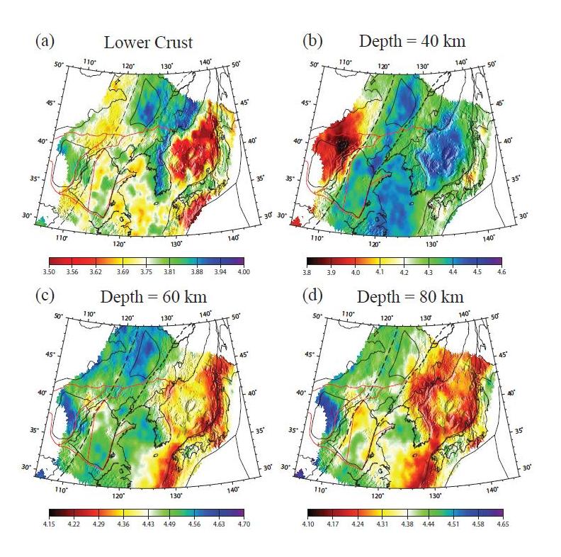 |
Four horizontal depth slices through the 3D Vsv model: (a) in the lower crust at a depth of 80% of Moho depth, (b) 40 km, (c) 60 km, and (d) 80 km depth. Color bars beneath each panel give the range of shear wave speeds in km/s (Zheng et al., 2011). |